Pictorial maps are a genre within the larger field of cartography that present a geographical area embellished with illustrations related to the places shown. The actual locations shown may be imaginary lands, and the pictures could be of people, buildings, historical events, or modes of transportation. The maps might contain humorous or whimsical touches, and they inevitably reflect the values of the time in which they are made. Pictorial maps with themes of love and marriage have been created since the 18th century. On this Valentine’s Day, we can take a look at some of these maps.
“From the 18th century onward, when the commercial print industry started to get involved in the celebration of the Feast of Saint Valentine, maps with themes of matrimony and love became popular. Printed in 1777 by Breitkopf in Leipzig, Germany, the map below situates Das Reich der Liebe (The Kingdom of Love) amid the “Land of the Happy,” the “Land of Lust,” the “Land of Youth,” and, alas, also the lands of “Mourning Love” and “Fixed Ideas.””
Nancy Rosin, “Unpacking A Box of Love,” February 13, 2018, The Metropolitan Museum of Art.

Digital Commonwealth Images from the 19th Century
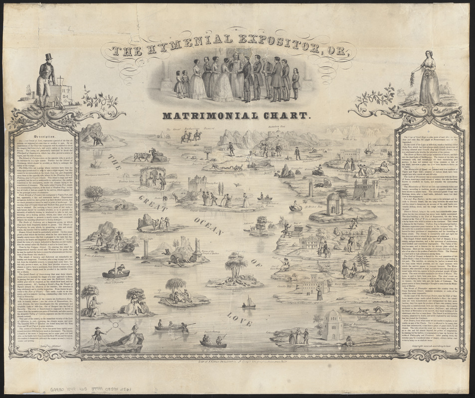
The “Description” on this pictorial map reads “The Great Ocean of Love represents a period of life that all persons are supposed at some time or another to pass. By an examination of the Chart, the voyageurs will be enabled to avoid the dangers that beset them, and arrive safely at the haven of felicity. . . ” Lovers are encouraged to avoid such places as the “Whirlpool of Impetuosity,” the “Shoals of Perplexity”, the “Quick Sands of Inconstancy” and numerous other traps.
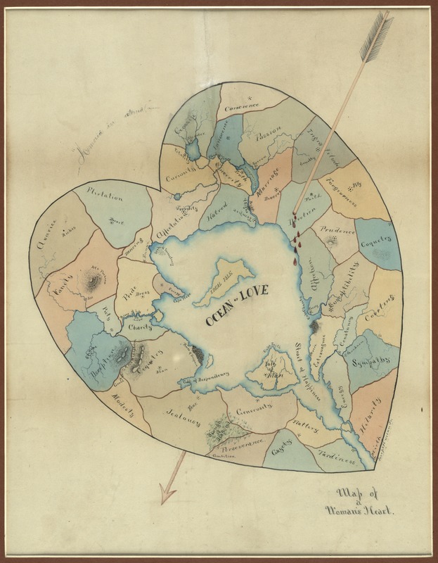
Also included in Digital Commonwealth’s collection of material from the Norman B. Leventhal Map Center is a “Map of a Woman’s Heart” by Joseph Husson. This is a manuscript map in ink and watercolor depicting the characteristics of a woman as geographic features of a heart. “Ideal Isle” is at the center of the map, surrounded by “Affection”, “Generosity”, and “Gayety”, but also, “Vanity”, “Avarice”, and “Hatred.”This map might be telling us more about the man who made it than about the woman’s heart.
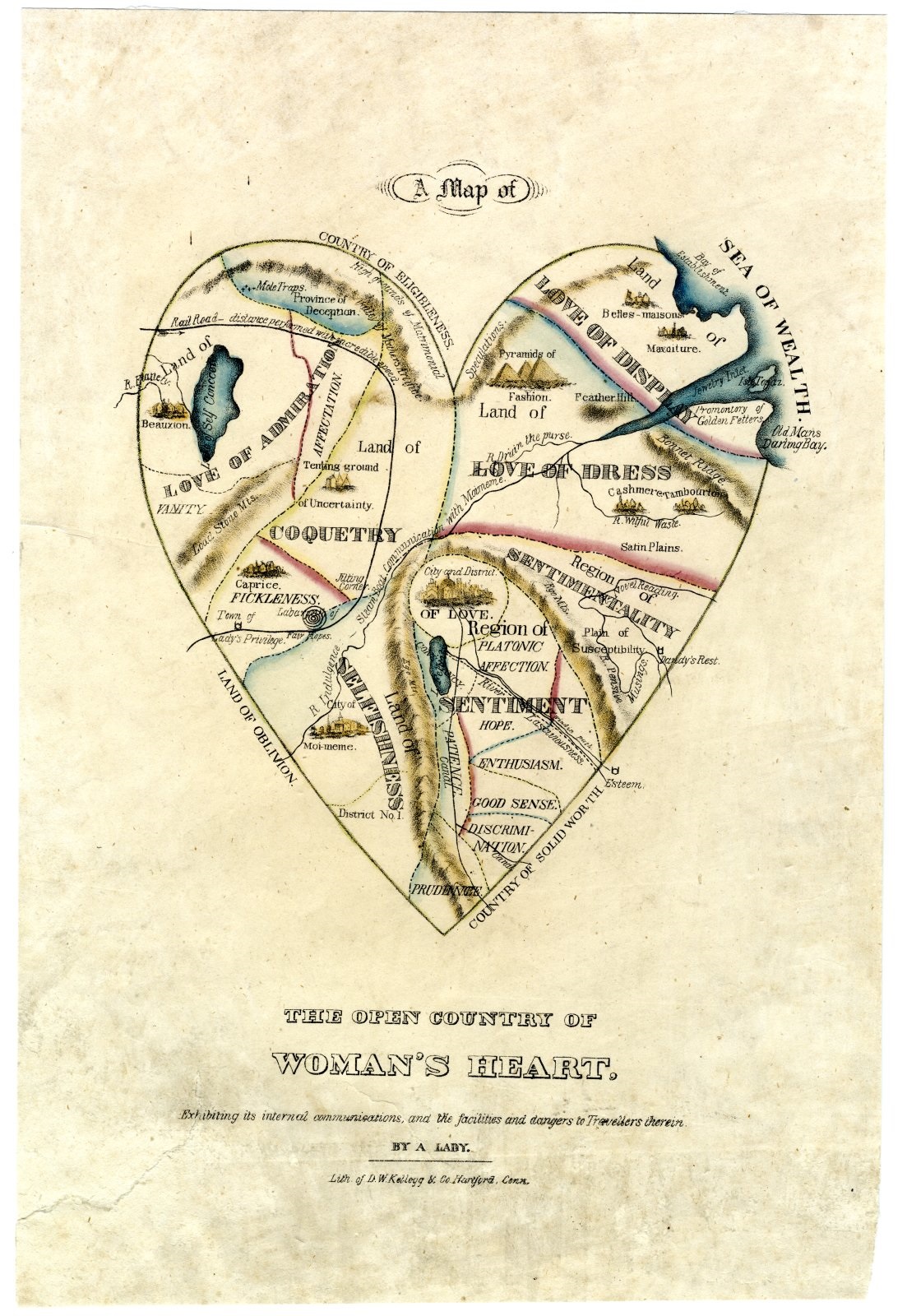
It may be that Husson got the idea for his sketch from seeing D.W. Kellogg’s “Map of the Open Country of a Woman’s Heart,” published prior to the middle of the nineteenth century. One of Digital Commonwealth’s member organizations, the American Antiquarian Society, owns a copy of this print and features it in an online exhibition, “Beauty, Virtue and Vice: Images of Women in Nineteenth Century American Prints” . The introduction to the exhibition reads like a mission statement for Digital Commonwealth. The prints are “useful to historians who would like to understand how nineteenth –century Americans thought about the world in which they lived. . . When read carefully and conscientiously, prints can be very useful documentary sources for understanding the past.”
Digital Commonwealth Images from the 20th Century
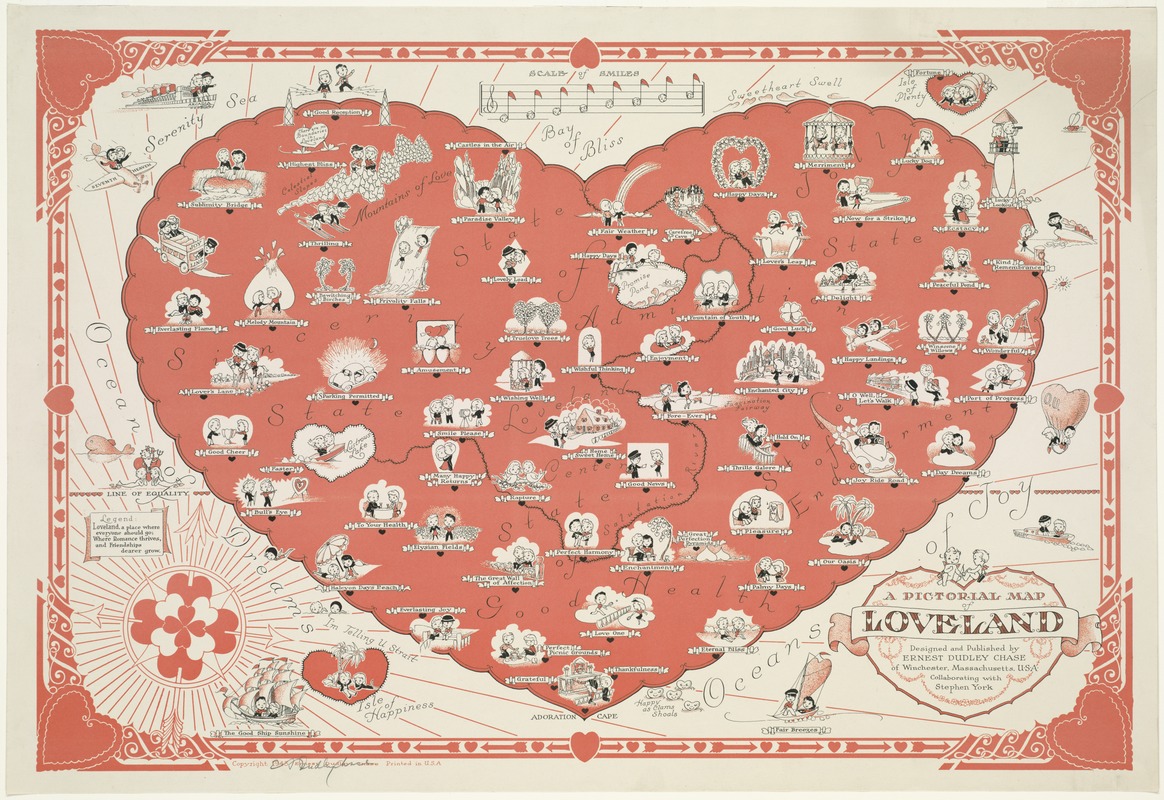
Pictorial maps in the twentieth century are less puritanical, less prescriptive. They are more whimsical. The genre evolved into a kind of popular culture art form. Ernest Dudley Chase’s “Pictorial Map of Loveland” shown at the beginning of this post is a perfect example. It is a “fictitious map of a heart-shaped place called Loveland [merging] the sentimentality of greeting cards with standard cartographic conventions.” Digital Commonwealth’s collection of the work of Ernest Dudley Chase includes 38 pictorial maps from the Norman B. Leventhal Map Center at the Boston Public Library. These maps range from drawings focusing on geographical locations in the Americas or on other continents to topical maps such as “Stamps of America” or “The Story Map of Flying: being a chronicle of man’s conquest of the air.”
“Born in Lowell, Ernest Dudley Chase (1878-1966) worked for Rust Craft Publishers, which printed greeting cards at its plant in Dedham. . . Chase’s maps were an extension of his work as a graphic artist for Rust Craft and also reflected an international trend toward pictorial mapmaking. These decorative maps, which experienced a resurgence in public popularity after 1913, are a genre in which the cartography is animated with illustrations of buildings, people, and animals. Often including historical references, the maps also frequently depicted airplanes and other modes of transportation. Borrowing from typical Renaissance cartography, Chase and other pictorial mapmakers used embellishments like compass roses, ornate cartouches, and decorative borders.”
Biographical information from the State Library of Massachusetts’s announcement for the 2009 Exhibit “Ernest Dudley Chase: A Worldview in Maps.”
Digital Commonwealth’s Pictorial Maps
Other pictorial maps in the Norman B. Leventhal Map Center’s collection are available online from Digital Commonwealth. Happy Valentine’s Day!